Monday, May 12, 2014

5/12/14 Mt Direction - TFS State Headquarters - TFS Cambridge

Jeremy Smith briefs the study group at TFS HEadquarters
Another full day in Tasmania.  We started our day by walking to the Tasmanian Fire Service (TFS) State Headquarters & Fire Operations Center.  The headquarters is their 911 center for the
state as well as finance,, communications, HR, equipment and dispatch.  In Tasmania, there are not two branches that handle rural and urban firefighting- both of those are handled under one agency, TFS. The headquarters has been here for 130 years and is a working fire station with two active brigades.  The center also issues all the public warnings for the whole state and for all agencies.  They have 230 brigades, 500 trucks, 5200 volunteers, 300 staff and 150 support staff.  The state control center stands up maybe 4 or 5 times a year when there are total fire bans in place, and then reps from all agencies come to work together at the Fire Operations Center: police, fire, Parks, Forestry Tasmania, etc.

Chief Officer Michael Brown said 1967 was the most serious fire year when 67 people around Hobart died.
TFS Chief Officer Michael Brown
 He says the weather has been changing - there is more drought and more severe weather days and extreme fire behavior. Dry liughtning is much more common than it used to be and the seasons are longer. Brown stressed that it is the relationships and cooperation among all the agencies, working across jurisdictional boundaries that makes it work so well.

Steve Whiteley, the Chief Executive Officer for Forestry Tasmania (FT) agreed, saying collaboration was the key along with interoperability.  He pointed out that FT values fire and feels its critical to land management.  FT focuses on training firefighters and helps train other agency personnel and contractors as well.

We were also honored with a welcome from the Minister of Police and Emergency Management, Rene Hidding, sort of a state commissioner level person, who came to say hello and talk a bit about planned burning from his viewpoint.

Then it was off for a field trip to Mt Direction where we heard from Kent, the Operations person, on a urban interface prescribed burn just across the bay from Hobart.  It was urban interface because of the homes in the immediate area and the significant view it would provide to all of Hobart.
The view of Hobart from where the burn was done
Kent says it took a  very long time, maybe a year, to get all the agencies and private landowners to agree to the burn. TFS, with an IMT, was burning but the land belonged to Parks and private landowners. Stakeholders involved in discussions were Southern Water Company, the prison, the aboriginal community, the power company because of a transmission line, there was a chlorine dump, a radio communications tower, and T & E species.  Each homeowner was visited and told about what the risk would be from the burn, and how bushfire risk would be reduced after the burn. Kent says it was not the best day for burning, a bit late in the season, but it had to be delayed long enough for the grape growers to pic k grapes to avoid taint from the smoke.  And it went very well, and set the stage for several other urban area burns done shortly after.

Then back to Cambridge to hear from Doug Taylor, a Senior Planning officer from Parks. Doug was instrumental in developing a Bushfire Risk Assessment Model, as part of the Strategic Wildfire Management
Doug Taylor - Senior Planning
Plan to try and balance perceived risk and actual risk.  It was very technical modeling stuff but here is the gist: he looked at likelihood and consequence to society of an event happening (which includes ignition potential, suppression capability, fire behavior potential and values at risk) and basically verified scientifically, what Parks has done historically.  He found that 8.5 out of 10 times they have been focused on bushfire risk where and when they should be.  The information and modeling he has done is shared with local community councils to help them design community plans.  There was a LOT more to his talk but its so far out of my lane I had trouble following!!


I have more on this day which I will finish later since this only gets us to lunch.  But its dinner time  now so check back!

Sunday, May 11, 2014

5/11/14 Styx Valley Coupe - Styx State forest - The Big Tree - Russell Falls - McPartlan Pass

Our first stop Sunday was up in the Styx Valley to look at a recent "coupe" (or "cut" in french!) designed to return the forest to its natural ecology through harvesting, followed by fire and regeneration.
"Coupe" area after harvesting, burning & reseeding.
They follow a strict Forest Practices Code and use the code to develop a comprehensive, area specific plan that goes from road construction to get to the planned area,  all the way to future plantations.  Areas are chosen based on animal populations, the age of the forest, etc and they try to do burns in patches so they have a variety of age classes in an area and enough long term retention of old growth trees.
Then the area is pretty much clear cut using conventional and sometimes cable harvesting.
Mark Neeland talks about harvest, burning and
regeneration. Behind him is a 6 year old project.
They get construction timber, high quality veneer timber and pulp timber out of it.  They also follow the code rules for harvesting seeds from the area, some of all the natural species in the area, to be used during re-seeding. Then they burn - using hand lighting, drip torches and heli-torch methods.  They light very hot in the center and get a good convection column going so it pulls inward, and then light the edges.
 About 10 days after the burn, but before it rains, they use an aerial re-seeder to replant the native seeds they harvested.


The  biggest problem is Wallabies. They prefer the regrowth and can wipe out an effort to reseed.
Burn & regen project
from the 1960's.
They tried a chemical called 1080 to poison the Wallabies but since it did not discriminate which mammals it killed and public outcry, it was banned. They are allowed to use traps but those only kill one at a time, are very expensive and have been relatively ineffective on the population. Successful reseeding remains a challenge.

Mark Neeland says they try to model the burns after what happens naturally in the ecosystem.  They don't have fires often but when they do, they burn intensely and burn everything.  And that's whats needed by the eucalypts seeds: bare ground with a good ash bed and sunlight.  They've used research to prove to the public that very hot fires are the best way to regenerate the forest. We also stopped to see a section that was burned in the 60's.  It's amazing how fast things grow - some of the stringy bark trees were 60 meters tall in 40 or 50 years.

Just before lunch, we stopped and walked through the Styx State Forest, home of "The Big Tree."
The Styx State Forest
Juan, Kevin and Brooke look up
at the "Big Tree."
 Some pictures here, but more are in the dropbox. The big tree is a Eucalypt species called Mountain Ash, also known here as Swamp Gum. Amazing and beautiful rain forest with a mix of the usual rain forest flora as well as huge Eucalypts.  The Big Tree and the Bigger Tree were nearly 90 meters tall and last burned 400 years ago.  Eventually, since the Eucalypts need to burn to regenerate, the forest will need fire. If not, the Eucalypts will die and all that will remain is rain forest.
Tony shows us the right way to
look at the big tree!


Russell Falls at Mt Field
National Park.
Lunch was at Mt Field National Park (a state park) where we went for a walk to Russell Waterfall.  Gorgeous falls about a 10 minute walk through what looks like a Jurassic rain forest. Do see more pictures in the drop box link to the right. 
And then back on the bus to go to McPartlan Pass, maybe 1000 feet in elevation and a complete change in fuel types. As high desert as it looks. the area gets 3000 millimeters of rain a year and even wet grasses burn the predominant fuel is Button Grass, but there is sedge, scrub Eucalypt and tree type Eucalypt, all mixed with stands of rain forest.  
McPartlan Pass

Because the area burns easily and is so remote, they use prescribed fires to lessen the spread of large fires and protect fire sensitive vegetation.  Although the only real fire risk is from lightning, they are often busy with other fires in more critical areas and don't get to these remote fires until they are fairly large. They use the rain forests as fuel breaks and count on "moisture of extinction" or high nighttime RH, to finally put the fires out.

Last stop was Lake Pedder, created in 1971 to become the largest water catchment in Australia.  It is used exclusively for hydroelectric power, although fishing and boating is allowed, as well as dipping for use on wildfires.
Lake Pedder Water Catchment
Had to post the Wallaby picture since we saw one!

5/10/14 Tasmania - Hobart - Sightseeing

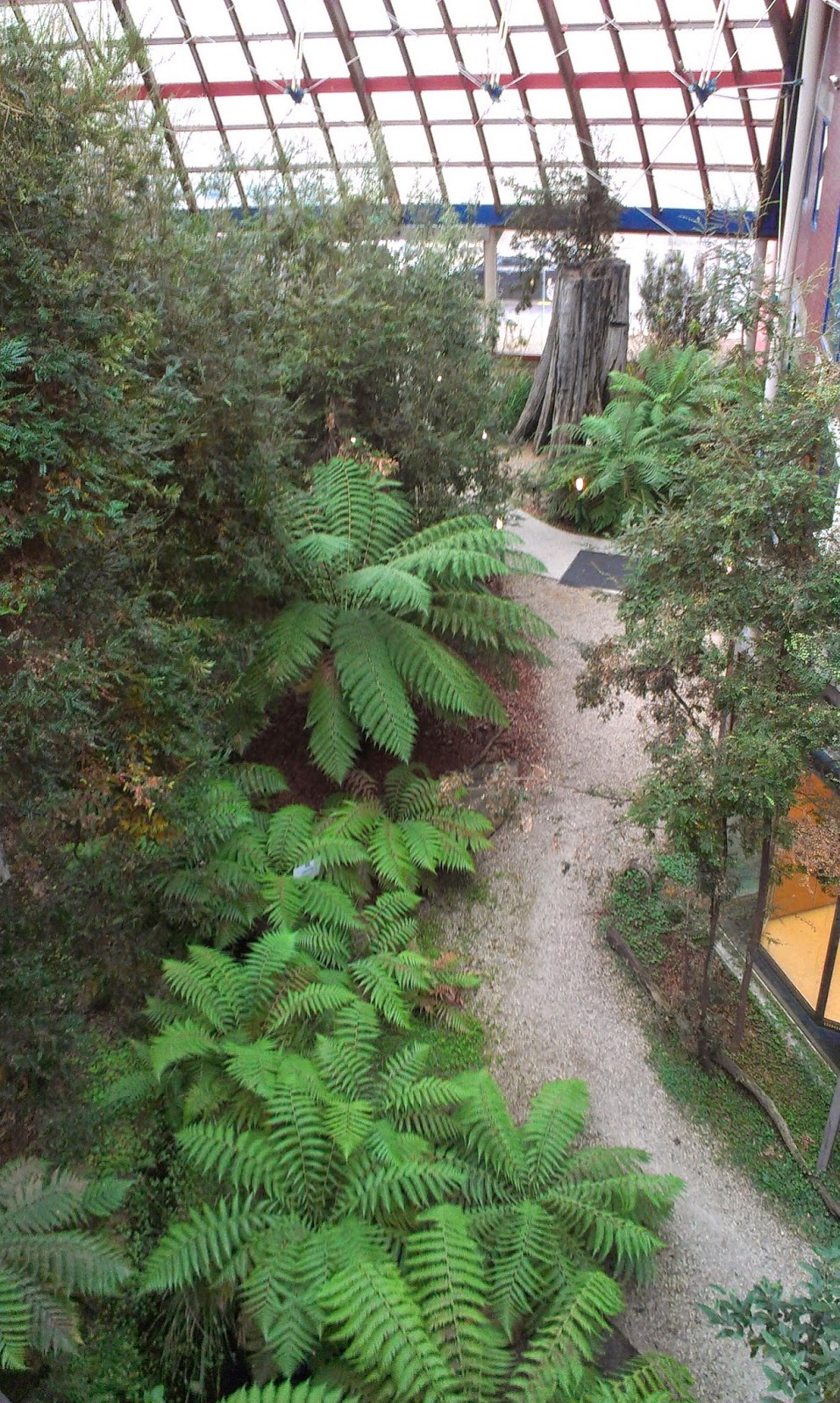
After flying to Tasmania Saturday morning, an island south of the Australian continent, we were met by Forestry Tasmania and taken to their headquarters office in downtown Hobart. They have an amazing office that used to be an old sawmill and uses a great deal of recycled material, including Ponderosa Pine from the 1800's.  It is planted with flora native to Tasmania and is a bit jungle like in the center atrium!

Tasmania is about 26,500 sq miles and is the 2nd oldest city in Australia, built in 1803. The area has a strong background in agriculture but also has a mining & a fishing industry. 500,000 people live hear but according to our hosts. it is an aging population as young people leave. Power here is almost all hydroelectric which are on the west side, the very wet side, of the island, which gets about 100 inches a year. The population is very anglo celtic, with a few asians, some african refugees and large aboriginal population, many of which are of mixed race.


20% of the land is forest, 40% private, 40% reserves. Forest lands are disappearing as the current political party, called the Green Party, gets them moved into reserves. The island is mountainous with the largest 1200 -1500 meter mountain in center of state.

Forestry Tasmania was the Forestry Department but became a corporation in 1994.  It is now a government business enterprise, like the Forest Corporations we saw in NSW and Victoria. They have 4 districts, a head office and 300 staff. Fire is used as a tool for fuels management and for regeneration. There is also a Parks and Wildlife service that has been a stand alone service since 1971.  They have the same use for fire, despite having a relatively small fire management section, but everyone participates in fire.

The Tasmania fire service was created in 1979 by joining the State Fire Authority, the Rural Fires Board and 22 urban brigade Boards. There are 230 fire brigades across state, with 250 career people and 4800 volunteer firefighters that provide fire protection on private land. The volunteers do both structure fire and bushfire and are trained for both and they have a strong community protection program.

Land owners pay a fire service levy but responsibility is shared by all services.  Minor fires are handled by Forestry Tasmania (FT) and Parks & Wildlife Service (PWS) with Tasmania Fire Service (TFS) acting independently but cooperatively. On large fires, TFS is the lead, supported by FT and PWS. On big fires, they do have complex incident management teams that are comprised of people from all agencies but they don't have standing teams like we do.  They are ad hoc and pull from who is available.

Tasmania has a robust Interagency Fire Management protocol which was started in 1990s. and is used by FT, PWS & TFS. It is a statement of cooperative principles that focuses on what important to Tasmanian agencies.  In 2014 they are on their 13th edition.


Saturday Market in Hobart
Then the rest of the day we had off to  sightsee, go to a Saturday Market  to shop and have dinner out.  As a port city Hobart has a beautiful dock area and really good seafood.
Tall ships in the harbor at Hobart

Seafood in the shop downstairs at Mures
where we had dinner

The harbor area again

Friday, May 9, 2014

5/9/14 South Gippsland - Jeff Pike - Wilson's Promontory

Epicormic growth from a tree burned
3 months ago
 DEPI District Mgr. Jeff Pike
 Had an interesting day with a fellow names Jeff Pike!  He is a District Manager for Dept of Environment and Public Industry (DEPI).  We headed south to visit some old burns and learn about some of the regrowth and other ecology of the area.  Learned a new word for me anyway, not being a tree person!  We learned about regrowth that is "epicormic." That is, after a fire, epicormic growth happens from under the bark or underground at the tree's base. Its how the regeneration begins for some species, but when the canopy finally grows, it shades the growth below and the lower growth dies.

The group listens at Wilson's Promintory.
Tea tree is the large bush in back
Then we made our way to Wilson's Promontory where Tea Tree has taken over the area.  It is not an indigenous plant and planned burns are helping get rid of it but it took some experimentation.


Undergrowth at Walkerville
 And finally, after a long day, we made a last stop at Walkerville, or something like that to look at another planned burn area where they are having trouble getting an opportunity, both with weather and public concerns, to be able to burn.  We walked into the area a bit to see the density of undergrowth and learned that spotting, because of bark,  is a far bigger problem in controlling fire than in the US.  Short term spotting can be 15 kilometers and long term, can be as much as 30 miles.

Anyway, long day. Very tired group. Had a late, but wonderful dinner at a resort near the Promontory with several of our hosts attending. Looking forward to a day in Melbourne with some time off.


5/8/14 Gippsland - The RCC - Hazelwood Mine Fire - Walhalla

Our hotel in Wahalla
NOTE:  This post will be completed later as its late in the evening so check back. I have posted a portion of the day.

We spent a very long Thursday covering a lot of territory.  I have to admit to much of it being a bit of a blur as we struggle to absorb so much information, so many places and so many new faces and acronyms!

Walhalla


We began our day at breakfast in the historic mining town of Walhalla where we had spent the night.  We heard from Steph Carr about the Fire Learning Network who role is to have strategic conversations with the public about fire. Communities approach the Network to ask for help is starting the discussion in their community, to asses what people already know from experience and build more knowledge about fire.  Steph emphasizes that she's not "selling" anything, nor is she defending the Department, but rather providing a neutral facilitator to help educate and get discussion going. She says there is no agenda, or if there is its set by the participants and is designed to create space where trust can be built.  It's an investment in relationships, she says, and can take a long time but has proven to be worth it. Allowing the community to talk about what THEY want to talk about, makes it easier for the agency to come back later to talk about what THEY need to talk about.

Walhalla is a beautiful town with a history based on the gold rush.  I won't go into the details but it was very pretty.  Lots of interesting old architecture and the owner of the hotel was happy to give us a colorful history of the town and the hotel.

Valley in Gippsland under which lies 300 years of
coal to power Melbourne
We drove to a district called Gippsland which provides much of the power for Melbourne.  The entire valley as far as you can see has power plants, run on coal, and it was here that the recent Hazelwood Coal Mine fire happened.  The fire spread from a bushfire into an open coal seam and created a complicated incident in which the fire, other agencies like public health and messaging where complex and challenging.

Getting a briefing from Peter West about how they
conduct risk assessments in places like Gippsland.
An enormous open pit coal mine
While overlooking the valley, we heard from Peter West, the leader of the East Central Bushfire Risk Landscape Team, talk about how they assess and analyze risk.  Since the risks came from many areas, not all similar (fire, coal mines, endangered habitat), they needed to find a way to compare apples and apples.  First, they group assets and assume if the primary assets are being protected, the secondary assets are being protected simply due to proximity.  So they try to find one treatment, perhaps a fuels burning project that will protect a number of assets instead of just one by pulling back and thinking at a larger scale.  They use a graph that looks at the same 4 measures for each risk: 1) define the asset geographically, 2) determine a specific risk vulnerability threshold ( like at how many feet and at what temperature will a hour burn? Or at what temperature is an ecological system destroyed),  3) Use worst case scenarios to establish a baseline and 4) apply the mitigation and determine residual risk. They have found this works as a common measure for many dissimilar things.

The Regional Control Center 


We also spent some time at the regional control center, like a city or regional EOC, and had an interesting discussion about the complications of the Coal Mine Fire.  Apparently, the big problem was communication between agencies in terms of coordinating messages. They were not adequately prepared to deal with both the fire AND the public health issues that came from the coal smoke and we had some discussion about how a JIC could help with that.  Currently, they do not use JICs and rely on agency reps to take care of that as well as be the agency liaisons.

I think we went somewhere else after that but I cannot remember as things are becoming a blur! An amazing amount of information and some really good ideas going both ways I think.


Thursday, May 8, 2014

5/7/14 Melbourne Water - Lookout Tower - CFA - Powelltown

Sorry about so few pictures again.  Really poor internet but there are pictures in the dropbox link to the right!!

Map of water catchment.  The yellow areas are
catchments or watersheds
Wednesday was spent about the importance of the water “catchments” or watersheds that serve the 4.3 million people in Melbourne and the efforts made to keep catastrophic fire out of that catchment. Melbourne Water Company, like the Forest Corporation, is a state owned corporation.  It serves as the wholesale water supplier to 3 retailers, also state owned, that sell the water to consumers. They are expected to make a profit and return a dividend to the government.

The land belongs to the Crown, which means its state land and is under the control of Parks Victoria.  While most National Parks (which by the way are owned by the state!) are open to the public, the water catchment Parks are closed to the public. Back in 1857 when the first catchment was built, the land was open but at some point the water got contaminated and many people died.  So they closed the parks, people stopped dying and the parks have remained closed ever since.

There are 9 catchments that supply water to Melbourne - some have dry forests and some have wet forests.  The wet forests supply 50% of the water but it’s difficult to maintain those forests with regular low intensity burning because, well, they’re wet and won’t burn!  Instead,in 2005 they created a strategic plan to burn the dry forests around the catchments, keeping them healthy and free of shrubs and other fuels that would carry intense fire into the catchment.  In addition, there are some areas with a 20 to 30 meters cleared between the general park land and the catchment to provide further opportunities to stop fires.
Fire tower at Upper Yarra Catchment

We spent the day at a fire tower owned by Melbourne Water that over looked the Upper Yarra Catchment which is about 395,000 acres.  Their objectives are simple: protect water quality and water quantity.  Some timber harvesting is allowed but its minimal, about 350 hectares a year and when harvesting is done, the water in that catchment is turned off for a year to protect water quality.

Much research has been done and is still being done about the impacts of fuel reduction measures in the catchment, on the water supply and quality.  They've looked at and tested clear cutting, thinning, stripping, burning, etc.  They continue to test the effects but they are fairly sure about the impact of severe, stand replacing wildfires.  If a severe wildfire significantly impacts a catchment there is a 50% reduction in water after 30 years.  This is because the regrowth after a fire, all the young trees trying to grow, suck up all the water for about 30 years. 
Upper Yarra Catchment
At 30 years, the stands have thinned themselves, there are significantly less trees because only the strong have survived, and the trees are few enough and old enough to not take up so much water. There is a graph the use called the Kuzera Curve created in 1985, that shows that after a stand replacing fire, it will take 50 years before recovery really starts and about 150 years before the trees and water supply are back to the way they were.

Fire fighting in the catchments focuses on aggressive initial attack.  Melbourne Water maintains 30 full time firefighters and adds 50 summer casuals and people out of the head office if needed when the season starts. They also maintain a ready supply of dozers, slip-ons (trucks with prepared modules that can just be slipped onto the truck) and other equipment so they are completely self-contained for firefighting. New fires are always lightning or non-arson because the catchments are closed and security is tight. 

Nigel talks about the critical role of roads
in the catchment as fire breaks.
Roads maintenance is a significant focus within the catchments.  There are some 1800 km of roads but they are only used by catchment workers so don’t impact the water and the roads people of Melbourne Water have depots within 60 minutes of any area of the catchment.  Some of the roads started as timber roads ages ago, but are now part of the road system maintained so they can get to a fire quickly with equipment and people.  They are started a Strategic Fuel Break Project to choose primary roads on ridge tops that are widened even further as fuel breaks.  All the roads are used to burn off of when necessary.

Fire would have an economic impact as well.  Upper Yarra Catchment is a completely untreated water supply and it gravity feeds right into Melbourne at a cost of about $20 per unit (I have forgotten the unit).  That compares to the water in treated and pumped catchments of $60 per unit so if something happens to the catchment and the water has to be treated or pumped, the cost goes up significantly.  Other impacts that are managed are the fire risk around the storage areas and the risk of pre-defined ‘slippage” areas where debris flows due to steep terrain impacted by severe fire, could impact the water supply.

Jill, with the Bushfire Risk Landscape Team, provided more information about a modeling tool called Phoenix Rapidfire.  Like FS Pro and other tools used in the US, it can spatially model intensity, convection, spotting and potential fire spread.  Across Victoria they have done modelling every 5 km, but in some critical areas they have now done modelling for every 1 km.  In those areas, they identify assets when running the model and use that to decide on planned burning to reduce risk to those assets. This is the benefit of having landscape level teams to look at risk and risk reduction, over and above jurisdictional boundaries.
We heard from Don Tompkins with CFA, or the Country Fire Authority, in the Yarra Valley area.  CFA is the equivalent of RFS in New South Wales and is responsible for firefighting and preparedness on private land. CFA relies on 65,000 volunteers and about 1000 paid employees, and has about 45 pieces of equipment.  About 400 of the volunteers are available at any one time, 24/7.  He spoke about fire refuges in communities and showed us a refuge in Powelltown.

Don Tompkins stands in front of the school in
Powelltown which is a fire refuge.
Refuges are a bit controversial.  They were requested and a few test refuges were built (the one in Powelltown is part of the pilot) after Black Saturday in 2009 when so many people were killed by bushfires.  But the focus toward private landowners has been personal preparedness, building resilient communities.  Some wonder if refuges make the community less resilient and more reliant, as some people just plan to go to the refuge.  Tompkins made it clear, they do not want people to include the refuge in their Bushfire Survival Plan.  It’s a place of last resort.

Don shows the control box available to
residents who enter the refuge during a fire.
The refuge in Powelltown is in the primary school.  Others are in fire stations or other buildings.  The refuge in the school is intended to let people survive an intense fire until it moves past; it is not a place to stay, has no food or water or other facilities for longer stays. But it is an impressive structure.  There is an entrance system connected to the state control center that has automated messages.  Inside, it will hold about 350 people (fairly crammed in) and has a cooling system to keep the building cool because it will be summer and because of the fire. 

Water tanks
There is a control box with step by step instructions on how to turn on power, turn on lights, turn on the air conditioner, and more.  They can monitor an emergency radio channel and communicate with the state control center. The glass in the building is specially made, all windows are mesh covered, outside is a cache of PPE, hoses, breathing apparatus, first aid kit, etc in case it’s needed.  There are two huge water tanks and a generator and 3 air conditioning units with an awesome amount of cooling power.
 Tompkins says its unlikely that more refuges will be built to these standards – this one was built when there were no standards. From now on, refuges will likely be a basic metal shelter or an improved underground bunker that are much less expensive to build.
At left is the generator and at right, one of
three, huge air conditioners


While in Powelltown we met a citizen, a woman named Pam who is a local government employee but also chairs the Powelltown Emergency Committee.  The community was asked if they were interested in being a pilot city to test the idea of community preparedness.  They said yes, and for about a year, the committee, met once a month to identify hazards and risks to their town. The committee is made up of about 10 or 12 interested people who were assisted by the Landscape team.  The regional team provided modeling information to educate the town about where fire would likely come from, what the intensity would be, and what assets it could potentially destroy.

Pam felt it was a goal of the community group to use this intelligence to inform the group on the best methods toward response and recovery and that it was the communities responsibility to be prepared.  They decided they wanted not just to survive but survive well.
Pam talks about her Community
Emergency Committee


First they looked at risks and bushfire was one but they looked at all hazards and assessed risks and consequences.  Second t hey looked at what they could do, alone and with help, to prepare and respond by looking at the skills of the people in town and the history of fire in the area. Pam says they tried not to duplicate the services offered by other agencies.  The focus not to find a way to stand alone, but to fill gaps in services and work as a partner to the other agencies that would already be responding.

They ID’s key assets, set up information points for residents, set up briefing and public meeting areas, identified informal shelter areas and identified where infrastructure needed to be improved to help with the plan.  After sending the plan to everyone in town, they had about 40% involvement.  However, after a fire Feb 9ht of this year where the plan was activated, they actually had about 60% involvement.

She says the key is the relationships with the other agencies which need to be rebuilt and maintained when key people move on. But she says community level preparedness is a large gap – there are state,  regional and local programs and help for individuals.  But help to allow a community to prepare together is not there.

Tuesday, May 6, 2014

5/6/14 Melbourne - Risk Management - Landscape assessment teams

This may be a quick post with no pictures as I wanted to get something up before we leave. We will not have wifi tonight so I will be absent for a day or two.

Learned a great deal yesterday.  Heard from a fellow name Lee who works for DEPI (Dept of Environment and Primary Industry) about Risk Management.  The words he used and the way he spoke about risk were very similar and in some cases identical to what the NIMO teams use when talking about it.  The difference is that when they do risk management here it's about reducing risk from wildfire or bushfire.  It's not about reducing risk to firefighters with better risk-based decision making.  But the process for evaluation and analysis is the same. 

There is also a huge focus on community engagement, even when talking about risk management.  Lee said they are clear with the public that "Risk Management through the use of prescribed burning" is not a panecea.  That burning will not solve their risk problems and, once again, he brought up "shared responsibility."  Its very clear here that the Aussies are very pointed in their community engagement, making clear that while the public can expect them to come when they call, that the agencies have clear expectations of the public that THEY will prepare by making their homes defensible.  Apparently, the losses suffered during the 2009 bushfires, continue to have an impact and the public remains willing to engage and take on its portion of the responsibility.

Community engagement has been a recurring theme here and winds its way through every discussion. It's important enough here in Victria that at the state and regional levels they hve a position called Community Engagement Specialist. This is not a PAO - they have communication and media people to do that work.  This is a person whose job it is to facilitate engagement with the community, like a full time liaison officer and reflective, I think, of the importance they place on doing so.  In fact they have said many times, they are trying very hard,  although not always successful, to engage in new ways; to not go to a community and say "This is what we think you should do," but rather go in and say "This is what WE think. What do you think and what do you want?" They are trying to allow communities to drive the effort, even sometimes scheduling a meeting and allowing the commuity to build the agenda around what  THEY want to talk about.

An interesting effort was the concept of Bushfire Risk Landscape Team.  These are teams of about 6 people, with different specialities: some work in modeling, some weather, some are ecologists, but basically interdisciplinary.  They work at a landscape level, across jurisdictional boundaries, to look at the best way to deal with bushfire preparedness and maintenance of biodiversity.  There is a team that serves urban Melbourne, and one team in each of the other regions.  The regional community engagement specialist work with the team to build relationships in the areas they want to work, plan public meetings and work with the Country Fire Authority in each region to mesh the landscape teams ideas and strategic plans, with those of the local CFA.

All in all a fascinating day, loads of information and a wonderful dinner last night. Today we are off to visit water catchment, or watershed areas about how they deal with fire across those landscapes.